 Today I was determined to figure out how to take real wold terrain data and use it to generate terrains in L3DT. It's not simple but with enough research/digging you can find out how to do it. Here I'll post a very simplified step by step on how to accomplish this.
First, decide what real world terrain you would like to generate, for this exercise I have decided on Fiji, an island in the South Pacific.
Secondly, you need to find the terrain data files which you can get on GeoCommunity. You'll need to sign up for an account but its free and having an account gives you access to the downloads you need. It took me a while to find exactly what I needed but here's your instant access.
I've found that most of the South Pacific island files are of the DTED (Digital Terrain Elevation Data) type, which is fine because the program we are going to use to generate the BT file will accept these as imports. Download your set of terrain DTED files and extract them to a location on your hard drive.
In order to complete the third step you will need to download and install VTBuilder. Once installed run the VTBuilder app and import your DTED files, multiple files can be selected and imported bulk. A little secret, use the Layer -> Import Data command to accomplish the import. As you import the files, VTBuilder will generate a map on the right side of the app window. Select the area which you would like to build a terrain for by using the Area Tool in the menu bar. Draw a box around the area using the tool. After it is selected, choose the Merge & Resample Elevation command from the Area Tool menu. Choose a path to save to and click Save. Later you will find yourself coming back to this window to fiddle with the map size controls for the best results, in the meantime just accept the defaults. This has effectively exported the file to the BT format.
The fourth step involves importing the file into L3DT as a Heightfield. Choose Import -> Heightfield from the File menu of L3DT, then choose the BT file you created in step 3. This loads the heightfield into L3DT. Now you can generate the water map etc. Have Fun!
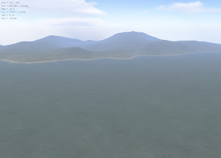
This is actually a finished map of one of the Solomon Islands.

No comments:
Post a Comment